So now that I have my whole region, and it’s (mostly) looking like I want to, I decided to start work on some of the basic transportation.
My thought is that I’ll get the main interstates up first, then some of the major highways, and then I can start laying out some of the cities.
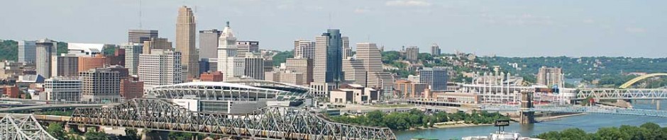
I started with downtown. I mean, when you’re alone and life is making you lonely, where can you go? WHERE. CAN. YOU. GO?!?! (Down. Town.).
As a side note, people that upload videos to youtube of songs, and make the videos crazy parts of the lyrics just crack me up.
Anyways….
Here’s what I’ve got so far.

Downtown area – that’s 75 coming in from the north, and 71 coming from the northeast.

Here’s what in real life is the Lytle Tunnel – 71 south (and 71 north) go underground. I haven’t quite figured out how to make that happen yet in SC. That’s 71 north in the picture, and 71 south isn’t quite done yet. The elevated highway is where 71 north comes across Fort Washington Way and splits into two – the right most lanes go underneath and into the Lytle Tunnel while the left-most lanes cross over them and start I-471 across the “Big Mac” bridge into Newport, KY.

And here is what in real life is the Brent Spence bridge, where 71/75 join together to cross the Ohio River. I don’t think that SC4 / NAM support double decker bridges, so I’m not sure what I’m going to do there. For now, I’m just leaving it as is. For comparison, here’s what the real map looks like – click for Google Maps.
So what do you think? Not a lot to show, right? Why am I even bothering to make a blog post about it? Oh, because “all this” has taken like 2-3 hours of work! Kinda depressing when you get right down to it!!! But don’t worry, we’ll get there
